Sacred pond and ridge

Indra Daha

A sacred pond on the Indrasthan ridge above Dahachowk, tied to the Indra Jatra legend. Free, open air, and best reached as a one to two hour hike with the view tower alongside.

Thankot.com Editorial Desk Last checked August 2026 7 min read
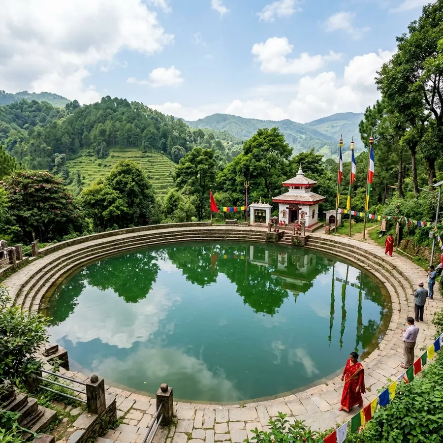
The Indra Daha pond with a white shrine on the ridge above Dahachowk
The pond on the Indrasthan ridge above Dahachowk.

Indra Daha is a small sacred pond on the ridge above Dahachowk in Chandragiri Municipality, north west of Thankot, and it is free to visit at any hour. Most people reach it as a hike of one to two hours from the road head at Dahachowk, though a jeep can get close to the top, and the usual visit combines the pond with the Dahachowk view tower and the Kalu Pande memorial park on the same ridge.

The pond matters for a story rather than for its size. In the tradition attached to Indra Jatra, the great Kathmandu festival of the god Indra, the king of heaven came down to this ridge with his mother and with the spirits of the recently dead, and the souls bathed here before making their way onward. Local accounts say bathing in the pond washes away sin, and some families still come on the first day of Indra Jatra to bathe.

What you get as a visitor is a quiet ridge at around 1,800 m with a pond, a couple of small shrines to Indra and to Manakamana Mai, forest on the slopes, and a horizon that on a clear day runs west towards Dhading and Gorkha and north to the snow line. It is a walking destination, not a monument, and it rewards being treated as one.

The Indra legend and why people bathe here

The traditions attached to this pond come in more than one version, and all of them should be read as legend rather than as documented history.

The version tied to Indra Jatra holds that Indra, king of the gods, came down from heaven and was accompanied on his return by his mother and by the souls of those who had died in the preceding year. At this pond the souls immersed themselves in the water before continuing their journey. Some families in the valley still mark the first day of Indra Jatra with a ceremonial bath here on the strength of that account.

A second version holds that Indra struck the ground on this ridge and drew water from it, and that the pond has been unusually pure ever since. A third describes Indra bathing here himself, having left his elephant tethered on a golden chain nearby. The place name Indrasthan, the place of Indra, carries the same association.

What the different accounts share is the idea that this water cleanses. That is what brings people up the hill on the festival day, and it is why the pond is kept and maintained by the community rather than left to the forest.

The walk up: routes and how long they take

Indra Daha sits above Dahachowk, which is off the highway a short distance past Thankot. The ridge is often quoted as roughly 6 km from Kalanki as the road runs, though the last stretch is steep and rough.

The usual hike

From the Dahachowk road head, a trail climbs through farmland and then forest to the ridge in one to two hours for a reasonably fit walker. It is a moderate walk rather than a hard one, on dirt paths and farm tracks, with the steepest ground in the middle section. Descending takes around an hour.

Longer versions

Walkers who want a full day link Indra Daha with the Kalu Pande memorial park and the view tower along the same ridge, and some continue towards Sitapaila or down to Thankot, which makes for a five to seven hour day in total.

By vehicle

A jeep or a motorbike can get most of the way up in dry conditions. The surface deteriorates in the monsoon, and a low-clearance car is a poor choice at any time of year.

What is on the ridge besides the pond

  • The Indra shrine at the pond, small and whitewashed, with the pond itself stone-edged.
  • A Manakamana Mai temple nearby, the wish-granting mother goddess whose main shrine is in Gorkha.
  • The Dahachowk view tower, a short walk along the ridge, giving an unobstructed circle of view over the hills. It is generally open through the day, with 8am to 5pm quoted for the tower at the neighbouring park.
  • The Kalu Pande memorial park, sometimes called Switzerland Park, with the samadhi and statue of the Gorkhali commander.
  • Tea shops and simple food at the road head and, in season, at the top.

There is no entry fee for the pond. The neighbouring park may charge a small amount at the gate.

When to go and what to take

October to March is the season, with the clearest air in the weeks after the monsoon breaks and again in midwinter. Spring is hazy. The monsoon turns the trail to mud and the leeches come out in the forest sections, which is a real deterrent from June to September.

  • Shoes with grip. The trail is dirt and loose stone, not paving.
  • Water and something to eat. Supply on the ridge is thin and seasonal.
  • A windproof layer. The ridge is exposed and noticeably colder than Thankot.
  • Cash in small notes for tea and for the shrine.
  • Sun protection. There is little shade above the tree line on the last section.

Go in the morning. Cloud builds over these ridges from midday for much of the year, and the view is the point.

Is it worth it?

If you want a monument, no. The pond is small, the shrines are modest and there is nothing to read on a signboard.

If you want a half day walking on a quiet ridge within an hour of Kathmandu, with a story attached to the water at the top and a genuine view west over country most visitors never see, it is one of the better options on this side of the valley. It also sits alongside real history: the commander buried on the next rise, Kalu Pande, led the Gorkhali army that took the valley, and the ground you are walking on is what he asked to be able to see from his grave.

How to get to Indra Daha

The starting point is Dahachowk, off the Tribhuvan Highway a short distance beyond Thankot on the north side.

  1. Get to Dahachowk. Local buses and micros run from Kalanki towards Thankot and Naubise; ask for the Dahachowk turning. Shared jeeps run the branch road up to the village.
  2. Walk from the road head. The trail climbs through farmland and forest to the ridge in one to two hours. Ask at the tea shops for the Indrasthan path; the route is used daily and locals will point you at it.
  3. On the ridge. The pond, the view tower and the Kalu Pande park are all within a short walk of one another.

By private vehicle, a jeep or motorbike can get close to the top in dry weather. Route and fare detail for reaching this side of the valley is on the getting there page.

Questions

Common questions about Indra Daha

The questions people search for most, answered with the figures we could verify.

Where is Indra Daha?
On the Indrasthan ridge above Dahachowk, in ward 1 of Chandragiri Municipality, north west of Thankot on the western rim of the Kathmandu Valley. The road head at Dahachowk is roughly 6 km from Kalanki, and the pond is a one to two hour walk above it.
Is there an entry fee for Indra Daha?
No. The pond sits on open ground with no gate and no ticket, and it can be visited at any hour. The neighbouring Kalu Pande memorial park, sometimes called Switzerland Park, may charge a small amount at its gate, and its view tower is generally open around 8am to 5pm.
How long is the hike to Indra Daha?
One to two hours up from the Dahachowk road head for a reasonably fit walker, and about an hour back down. The trail runs through farmland and forest on dirt and loose stone, with the steepest section in the middle. Allow half a day for the round trip with time at the top.
What is the legend of Indra Daha?
Local accounts say that Indra, king of the gods, came to this ridge with his mother and with the souls of the recently dead, and that those souls bathed in the pond before continuing onward. Other versions say Indra struck the ground here to draw the water, or bathed here himself. These are legends, not dated history.
Can you drive to Indra Daha?
A jeep or motorbike can get most of the way up the ridge in dry conditions. The surface is rough and becomes difficult in the monsoon, so a low-clearance car is a poor choice at any time. Most visitors walk from Dahachowk, which is the more enjoyable approach anyway.

Planning a visit to Indra Daha?

Fares, bus routes, journey times and the months when the western rim is at its clearest.