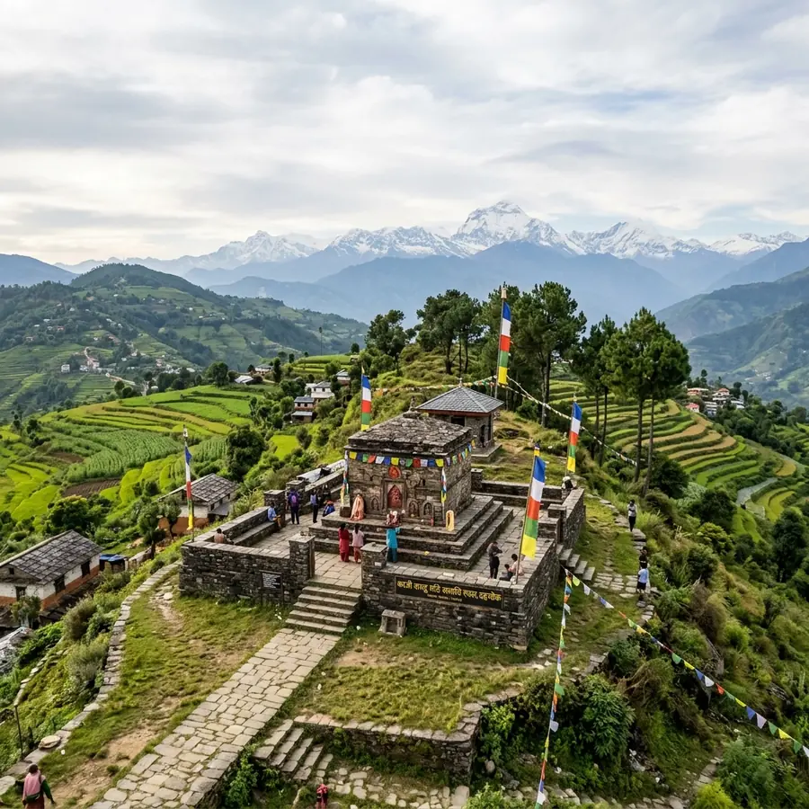
Memorial and viewpoint

Kalu Pande Memorial Park, Dahachowk

The cremation site and samadhi of Kaji Kalu Pande, the Gorkhali commander killed at Kirtipur in 1757, on a ridge above Dahachowk with a view tower and a Manakamana shrine.

Thankot Heritage Research Team Last checked August 2026 6 min read
The stone memorial to Kaji Kalu Pande on the ridge above Dahachowk
The samadhi marking where Kalu Pande was cremated.

Kalu Pande Memorial Park sits on the ridge above Dahachowk in Chandragiri Municipality, north west of Thankot, and marks the place where Kaji Kalu Pande was cremated. It holds his stone samadhi, a statue, inscribed panels about his life, a small Manakamana temple and a view tower that is generally open from around 8am to 5pm. Locals also call the site Switzerland Park for the look of the ridgeline around it.

Kalu Pande was the Kaji, or chief minister and commander, of the Gorkha kingdom under Prithvi Narayan Shah, and he led the Gorkhali forces through the early years of the campaign to take the Kathmandu Valley. He was killed at the first battle of Kirtipur in 1757, twelve years before the campaign finally succeeded. Local accounts say he asked to be laid where he could still see his homeland of Gorkha, and the ridge does look west in that direction.

For a visitor the site works as two things at once: a place with real weight in the history of how Nepal came to be a single state, and a straightforward hilltop picnic and viewpoint an hour from Kathmandu. Most people come for the second and leave having read the first.

Who was Kalu Pande?

Kalu Pande was a Nepalese statesman and general of the Gorkha kingdom, appointed Kaji by Prithvi Narayan Shah and effectively the architect of the early phase of the unification campaign. He is credited in the standard accounts with the diplomacy that secured alliances for Gorkha before the fighting began, and with the strategy of strangling the Kathmandu Valley's trade rather than assaulting its cities directly.

That strategy ran through Thankot. Controlling the western pass meant controlling the goods coming up from the plains, and the blockade of the valley is the reason a small town on a hill appears so often in the history of the period.

Kalu Pande died at the first battle of Kirtipur in 1757, a defeat for the Gorkhali side. The campaign continued without him for another twelve years, ending with the fall of Kathmandu in 1769. The unification chronicle page sets out the sequence in full.

What is at the park

  • The samadhi. A stone memorial marking the cremation site, the reason the park exists.
  • The statue of Kalu Pande, standing at the centre of the grounds.
  • Inscribed panels and photographs setting out his life and role in the campaign, in Nepali.
  • The view tower, giving a full circle of view over the hills. Generally open around 8am to 5pm.
  • A Manakamana temple, small, said locally to have been founded by Gorkhali soldiers after a victory.
  • Open ground used for picnics, and space to camp with permission.

Facilities are basic. Expect tea and instant noodles rather than a restaurant, and bring your own water for a longer stay.

The view, and why people call it Switzerland Park

The nickname is about the shape of the country rather than any resemblance to the Alps: green ridges falling away in layers, terraced fields, scattered farmhouses and no city in sight. From the tower the view runs north and west across Dhading towards the Gorkha country, which is what gives the local account about Kalu Pande's burial its force, and east back over the Kathmandu Valley rim.

On a clear morning between October and February the snow line is visible to the north. By late spring the haze usually closes it down. As on every ridge on this side of the valley, the first two hours after sunrise are the best of the day.

Getting there and combining it with Indra Daha

The park lies on the same ridge system as Indra Daha, and the two are almost always visited together. The pond, the view tower and the samadhi are within a short walk of one another, and a day that takes in all three from the Dahachowk road head is the standard outing.

Walkers who want more distance start lower, from Sitapaila or from Thankot, and climb the full ridge, which turns it into a five to seven hour day. Anyone short on time can get a jeep most of the way up in dry conditions.

A small gate charge may apply at the park. Bring cash in small notes; there is nowhere on the ridge to change a large one.

When to go

October to March for the clearest air and the most comfortable walking. Winter mornings are cold on the ridge and worth a warm layer. The monsoon, June to September, brings mud, leeches in the forest and cloud that closes the view entirely, though the hillsides are at their greenest.

Weekends bring Kathmandu picnic groups, particularly in the November to February season. A weekday will leave you close to alone at the samadhi.

How to get to Kalu Pande Park

Access is from Dahachowk, off the Tribhuvan Highway a short distance beyond Thankot on the north side, roughly 6 km from Kalanki by road.

  • By public transport: take a westbound bus or micro from Kalanki and ask for the Dahachowk turning, then a shared jeep up the branch road to the village.
  • On foot from the road head: one to two hours up the ridge on farm tracks and forest path.
  • By jeep or motorbike: possible most of the way in dry conditions. The surface is rough and gets worse in the monsoon.

The getting to Thankot guide covers which services run from which stand and how long they take.

Questions

Common questions about Kalu Pande Park

The questions people search for most, answered with the figures we could verify.

Who was Kalu Pande and why is there a park for him?
Kalu Pande was the Kaji, or chief minister and commander, of the Gorkha kingdom under Prithvi Narayan Shah, and he directed the early phase of the campaign to take the Kathmandu Valley. He was killed at the first battle of Kirtipur in 1757. The park stands on the ridge where he was cremated and holds his samadhi and statue.
Why is Kalu Pande Memorial Park called Switzerland Park?
It is a local nickname for the look of the country around it: green ridges falling away in layers, terraced fields and scattered farmhouses with no city in view. The name has stuck well enough that maps and hiking listings often use it alongside the official one.
What are the Dahachowk view tower hours?
The tower in the park is generally open around 8am to 5pm. The pond and the open ground around it have no gate and can be reached at any hour. Confirm locally if you are planning to be there for sunrise or sunset.
How do you get to Kalu Pande Memorial Park from Kathmandu?
Take a westbound bus or micro from Kalanki towards Thankot and get down at the Dahachowk turning, then a shared jeep up to the village. From the road head it is a one to two hour walk to the ridge. A jeep or motorbike can get most of the way up in dry weather.
Can you combine Kalu Pande park with Indra Daha?
Yes, and most visitors do. The samadhi, the view tower and the Indra Daha pond sit within a short walk of one another on the same ridge, and a single day from the Dahachowk road head covers all three comfortably.

Planning a visit to Kalu Pande Park?

Fares, bus routes, journey times and the months when the western rim is at its clearest.